Wednesday, 2 July 2025

Does this count?

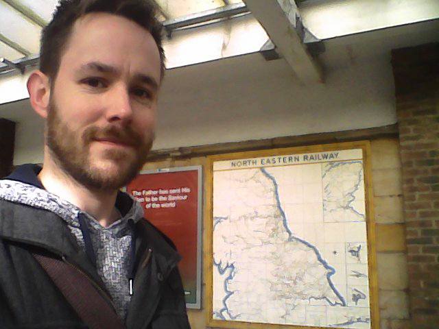
So I've been to the awesome Beamish Open Air Museum today, with just so happens to include a reconstructed North Eastern Railway station,  originally from Rowley in County Durham...

Rowley

So as well as proving I haven't completely forgotten about this blog, also shows the world just how grey my beard is getting.

Alas there were no trains running on this demonstration line today, but I did manage a short trip on the Pockerley Waggonway, behind a replica of Puffing Billy, and a couple of trips on trams.

To paraphrase a certain balding, plasticine, cheese-lover, it's been a Grand Day Out.

Puffing Billy

The two trams on which I travelled

An advertisement for a large pig

Possibly the above-mentioned large pig...


Monday, 1 May 2023

Unplanned Platform Cattery

So yesterday, inspired by the continuation of £2 bus fares and the realisation I've only got a month left of my English Heritage membership, I took a jaunt out to the Howardian Hills. The Coastliner dropped me off at Whitwell Hill, and then it was a pleasant ten to fifteen minute stroll, down country lanes to Kirkham Priory.

Oddly, despite living reasonably nearby for the past 30 years, I've never actually been into the Priory ruins until now. They're ok - quite fragmented of course; clearly been bashed about somewhat over the past 400 years or so, but quite enjoyable to explore. Very good views across the Derwent to the York-Scarborough line, and the picturesque disused station (Kirkham Abbey, last used by passengers 93 years ago).

I've been to Kirkham Abbey station already - about 9 years ago I think, in my first few weeks of pretending to be a blogger, before I realised what a silly impractical task I had set myself, but took some pictures anyway. I do like a classic North Eastern Railway signalbox. I wonder if the brick wall at track level is the last remaining fragment of the Scarborough-bound platform?

But anyway. My choice at this point was to head back up the hill to the bus stop, and get the next Coastliner back to Scabs, or have a further explore. Luckily I'd brought a trusty orange Ordnance Survey map of the area, just in case, so opted for the latter. The next stop towards York, on the Big Tile Map, is/was Barton Hill. The OS shows a footpath along the river bank, but I know from previous experience it can get absolutely disgusting, and my boots are not particularly mud-proof, so I opted for the "inland" route. The river does a big loop here anyway, so going over the top of the hill would be much shorter anyway. 

I followed the road back round the back of the signalbox, and then took a signposted footpath off to the left, and headed steeply into the bluebell-carpeted woods. Once at the top of the hill, it was a pleasant stroll along another country lane, to the tiny village of Crambe. It has a church (St Nicholas's) - which was open and contains an excellent selection of secondhand books for sale in the porch - a phonebox (which still has a phone in it, rather than a defibrillator) and a postbox. That's about it. No pub, no shop, not even a roadside stall selling eggs and jam. What is the world coming to?

After passing through this teeming metropolis (maybe it gets more lively on a weekday?), my route took me through a field of sheep, then down a long hill, overlooking the Vale of York. I suspect if the sky had been clearer I could probably have seen the Minster on the horizon, but that's just a guess.

At the bottom of the hill, the lane crossed the railway again, at Barton gatehouse. Apparently if you want to take a herd of cows across the track you have to phone the signalman. There was a poster saying if there's no answer, the signalman might be on strike, so you'd have to wait. There were no cows waiting to cross, so I assume all was well.

Once through the gates, the lane led me to the village of Barton-le-Willows, which although larger than Crambe, was just as quiet. Their phonebox is now a defibrillator, and their church is now a house, but they do have a gin distillery. How times have changed.

Barton Hill (1)
I continued through the village, and out the other side, and reached the old station at Barton Hill. It looks very similar to a lot of other rural stations on the former York & North Midland Railway, and has a surprisingly modern-looking signalbox. I took a crap selfie, standing in the middle of the road, as can be seen here --->

Please excuse my hair - it was windy, and whichever angle I stood I ended up looking dreadful, so this is the best of a bad bunch.

But anyway, back to a rail-related theme, I'm not sure why the signalbox is so out of keeping with the rest of the station. It looks sort of 1930s-ish, which would've been after the station closed. I'll have to investigate - I'm sure I've got a book somewhere which will explain...

After that, I checked my bus timetable, and discovered I was about to miss another bus, but that turned out to be in my favour. While pondering the architectural origins of the aforementioned signalbox, I was tormented by a niggling doubt about the station. I had a vague idea that all was not what it seemed, and on returning home I discovered I was right...

Barton Hill (2)
At some point, and for some reason (possibly connected with road works?) Barton Hill station moved, not far, just a few feet really, but that meant the station building I had posed by wasn't always the station building! For reasons of accuracy (as if that's actually important, and as if anyone even reads this rubbish anyway), I took another picture down by the other station building too. It's on a dead end road, which leads to an out-of-use level crossing, on what was the A64, before it was realigned. I've no idea which building was the station at the time of the Big Tile Map, but for completeness's sake I took another picture, where my hair looks slightly less offensive.

So that was that. Or was it...

On the way back to the bus stop, I caught a glimpse of something mysterious in the undergrowth. On further inspection it turned out to be a disused miniature railway, running through the trees. It looks long-abandoned, but still quite complete. On the bus home - Wifi on a bus! Very modern - I found a reference to it, admittedly from 2014... Apparently it belongs (belonged?) to a guesthouse called "El Paso", and was open to their visitors. No idea if that's still the case... Curious...


Thursday, 7 July 2022

Better late than never...

 Apologies for the lack of activity recently (and by "recently" I mean "over the past four years") - I expect you can guess what a large reason behind that was. But no matter...

Yesterday, myself and Thom went on a rail-based adventure. It was my first trip onto the Harrogate line since 1996, and I was pleased to note that despite the intervening years, some things I recalled are still there - most notably, the little narrow-gauge tracks that run around the plant nursery next to Poppleton station. I seem to recall the nursery used to belong to British Rail, for refilling planters across the North Eastern Region. I may be wrong?

But anyway, the main purpose of the trip was to meet up with Scaramanga, and explore Knaresborough - a town which, though some curious coincidences, I have never visited before, in all my 41 (ugh) years.

Knaresborough railway station appears to have been designed by a railway modeller who didn't really have any room for a realistic location, but *really* wanted a tunnel, and a station, and a level crossing, and viaduct, so decided to shove all the elements as close together as possible with no thought for common sense... It's great (if a little silly) - and that's before I mention the signal box attached to a row of cottages...

As well as mucking about on the station, we had a walk along the river (via a sausage sandwich and a pot of tea) to the Chapel of Our Lady of the Crag (which was closed). We clambered back up the side of the river gorge to the castle, and courthouse museum (which wasn't closed) - the latter even has a small display of rail related items, among other curios.

After that we pottered about in the town - had a pint in a pub by the market square, and another in a pub overlooking platform two, and then trundled our way back home, via York where we parted ways with Scaramanga. All in all, a good day


Lastly, Apologies for the random placing of photos in this blog post - I appear to have forgotten how to do it neatly!


Thursday, 17 May 2018

Insert Hilarious Title Here


An unintentional bit of Platform-Cattery happened on Tuesday. Thom and I went for a trip to Fort Paull, near Hull, to relive a bit of my childhood. When I was a wee bairn (?) I made several visits to the erstwhile Museum of Army Transport in Beverley, where the main attraction was a large grounded aeroplane - a Blackburn Beverley, no less - which one could go inside. It is now in the aforementioned Fort - a Tudor/Napoleonic/WW2 military establishment on the banks of the Humber - and one can still look inside. It hasn't changed, except I remember there being more headroom.

But anyway, train-wise, apart from a Military Transport Corps dining carriage, Fort Paull is a bit of a non-starter, having never been connected to any sort of railway network. It more than makes up for it in amusement value though. Another attraction from the time when I was a wee bairn (??) was the Friargate Wax Museum in York (also closed. Flippin' 'eck I'm getting old). If one ever wonders where old waxworks go when they die, then we have the answer - and that answer is Fort Paull!

Some of the waxworks make sense - Henry VIII is fairly relevant to a Tudor fort, obviously, and a tableaux featuring Queen Victoria can be fitted into the timeline, as can that little Austrian bloke with the bad hair and the funny
'tache. Some of the others however... Hmmm...

One of the rooms featured a model of Queen Henrietta Maria, which looked suspiciously like Princess Di in a drag outfit, and the wax model of a blacksmith making horseshoes may, or may not, have once worn a glittering shellsuit and lots of gold jewellery... Now then, now then...

But anyway, I digress. After the excitement of seeing a host of upcycled 1980s celebrities, we had a drive down to Holmpton, to the well-signposted Secret Underground Bunker, and in doing so, almost ran over a chicken while doing a thirteen point turn at Keyingham old station, enraged a massive dog at Ottringham station, and committed some minor acts of trespass at Patrington.


Keyingham
All three stations were once on the line from Hull to Withernsea, built by the Hull and Holderness Railway and opened in 1854. The last passenger train rain in 1964, with complete closure a year later in 1965. There was a further station between Ottringham and Patrington - namely Winestead - but as I was navigating using my Yellow 1930s Map we missed it completely, it having closed in 1904 and thus not being marked. Bugger. I suppose it's quite appropriate though as I'm off alcohol this month. One for a future visit...


Ottringham

Patrington
Anyway, the Secret Underground Bunker was shut, so we went to Hornsea and ate pies. A fine end to the adventure.

Thursday, 3 May 2018

Em-Barras-ment

Further adventures with Thom - no particular plan in mind, other than driving about. Basically I enjoy any excuse to mess about with the SatNav, and Thom is a willing victim travelling companion.

First of all I programmed us to go to Muker, in upper Swaledale, but changed my mind, and we switched it off altogether. I had my yellow 1930s Bartholemews Touring Map, so we wouldn't get completely lost... First diversion was Redmire, current terminus of the Wensleydale Railway and also loading point for Ministry of Defence artillery trains, but alas there were no tanks (much to Thom's disappointment), and heritage trains weren't running either. The dogs were were pleased to have a run about on the car park though.

Redmire (Apologies for Hat Hair)
The main station building is now owned by the Scouting Association, and sees (during the season) trains coming up the valley from Leyburn and Bedale, but it was formerly a small intermediate halt on the line from Northallerton on the ECML to Garsdale on the Settle-Carlisle, and closed to British Railways services in the 1950s. I'll have to come back again by train one day.


Just around the corner from Redmire, is a place who's name should be very familiar to Game of Thrones fans - the small village of Castle Bolton. Curiously, the castle in said village is named the other way round - Bolton Castle. It's a great place to visit. The castle is huge, and a good combination of ruinous and restored - I was particularly enamoured of Mary Queen of Scots' bedroom - with other interesting attractions in the grounds, such as
wild boars, falconry displays, a vineyard and a dyer's garden.


There's a very well-stocked gift shop - I was seriously considering buying a drinking horn, but eventually decided on a handmade jug instead - suitable for mead or wine I reckon. 

We didn't make use of the tearoom, but hopefully, if there's sausage on the menu, it isn't the same as those on Game of Thrones... Ouch.

After an hour or so, we tootled off, further up the valley, passing some nice waterfalls, a good selection of fighter planes, and a hell of a lot of sheep. Next stop was Hawes - but not for cheese, I can't abide Wensleydale cheese (or Cheshire, if you're interested). The old station there is now the Dales Countryside Museum, and was formerly the boundary between the North Eastern and Midland Railways. The NER provided all services eastbound and the Midland all to the west.

Hawes (with added hat)

There's a train parked in the platform, with three carriages used as exhibition space for the museum. I had a look inside - quite an interesting array of things including old church fittings, taxidermied animals, and a curious musical instrument known as a "Serpent". It was only as I exited the carriage nearest the engine that I realised I was supposed to have paid... Oops.


We made a speedy getaway up to the dale head, and then zoomed along the reasonably flat road across Mallerstang Common, all the while running parallel to the Settle Carlisle line. No trains passed us, sadly, but there were some cool viaducts to look at, and we got a chance to explore the ruins of Pendragon Castle. It's fairly small - more of a fortified manor I suppose - but the dogs (and Thom) appreciated the chance to stretch their legs and have a wee (that part, Thom didn't do...)

Last station visit of the day was Kirkby Stephen - later renamed Kirkby Stephen East. I had actually been here once before, in the late 1990s, when the station was abandoned, used only as a bobbin mill for a long time. Now it is run by the Stainmore Railway company, and is being developed as a museum with train rides available. Alas, it being a Wednesday in May, it wasn't open to look round, so I had to make do with a rather dreadful picture of myself outside the main gate.

Kirkby Stephen

Kirkby Stephen (East) used to be a fairly major junction. Trains from County Durham, across the Pennines, could continue west towards Tebay on the West Coast Main Line, or could turn northwards, up the Eden Valley towards Appleby and Penrith. Nowadays however, they can only go couple of hundred yards, then turn back, but the plan is to extend the line as far as finances allow. They have recently built a large modern engine shed, and have constructed a traditional water tower, using the tank from Wharram
(on the Malton to Driffield line), and reclaimed bricks from Barras...

Ah, yes... Barras... my nemesis...

...

But wait! On the return journey, we called at Barras again! Hurrah!

Barras
And this time I haven't deleted the picture in error, and it isn't foggy so it's even possible to see the background! Admittedly I look like an extra from Last of the Summer Wine, but you can't win 'em all...

Monday, 16 April 2018

FogSpot

Last Tuesday, Thom and I had a free afternoon, so went for a drive into the Dales. The scenery may have been stunning, with expansive moorland vistas all round, but I couldn't tell you, 'cos it was thick fog for the entire journey.


We went across to Barras, way up in the high fells of Cumbria first - and irritatingly, although I took a photo of myself, I accidentally deleted it in the uploading process, so at some point I will have to go back - perhaps when the weather is better. But anyway, for now this will have to do. This is the former stationmaster's house, on the westbound platform. There was a cat hanging around, but it fled at
the sight of Thom's dogs, so no photo of that either.


On the way back, we came back along the A66 - joining a speeding flow of heavy traffic in a thick
pea-souper was quite a hairy experience, but I'm not dead, so we obviously did something right. We stopped off to have a nose around Bowes. It's over twenty years since I was there last, and it's not looking at its best. The Pennine weather is definitely taking it's toll.

Took an updated photo - I'm not sure I'm ageing any better than the stonework, but I'll blame that on my phone camera. The selfie mode is always considerably blurrier (Is that even a word?) than the normal side. Perhaps I ought to invest in a new one. Ugh.

   
Bowes
                                           

Sunday, 18 June 2017

Feeling Hot, Hot, Hot

So, like any normal person, I decided, on the hottest day of the year, to spend several hours on a bus to visit a post-apocalyptic industrial wasteland. Yes - that's right: Middlesbrough!

The journey did not start well - the 93 was packed with pensioners, of course - one particularly irritating specimen, with teeth like old wax crayons, repeatedly announcing to anyone who'd listen that she "lives near the seafront you know". Thank heavens for headphones.

Once I'd blocked the surrounding chatter, I was fine. From Robin Hood's Bay as far as Whitby a very attractive young hiker came and sat beside me - he had very good legs - and then Gotho boarded in Whitby. The mood was lightened even further by a very jolly dog on the seat in front, who wanted to make friends and kept poking her head through the gap, like an excitable child on a school trip.

Not entirely sure about this
Once in the 'Boro, we exchanged some black (of course) jeans in Primark - the main purpose of the trip - and wandered up to the riverside. The Transporter Bridge was once again closed for lunch, but we decided to wait this time, and had a stroll along to the big sculpture thing that looks a bit like a giant version of one of those bags oranges come in. Not quite sure what it's supposed to be, but it's quite impressive all the same.

Back from the Grand Canyon
Once the Transporter Bridge had finished eating its sandwiches, we boarded. I hummed the music from Swan Lake, but it was completely lost on Gotho, as evidently he has never watched Billy Elliot. It's 60p each way, and is a surreal experience. It's not so much a bridge, as a ferry dangling on strings - very smooth and a lot quieter than I expected.

Pleasantly rural
Over the river, in what I presume is (or at least was) County Durham, is the old railway station at Port Clarence. It's been closed to passengers for decades now, but there is still a freight line running past at a slightly higher level, towards chemical works at Seal Sands. It's an odd place - minutes away from Middlesbrough town centre, but like a remote village from a different time altogether. There's the station building, a tiny little cafe selling bacon sandwiches, a row of railway cottages, and The Station Hotel, offering a week's B&B accommodation for £75 quid. Bargain.
Port Clarence

Old signal post
On the Big Tile Map, Port Clarence is at the end of  a branch line, with only one intermediate station - Gotho agreed we could walk along the main road and see if there was any evidence of it.

By this point, it was like standing in front of an oven. Gotho went in to a Londis with bricked up windows and bought a bottle of Goth Juice (well, Sprite, but Goth Juice is funnier). We passed a war memorial, a couple of rows of council houses with the requisite handful of shirtless chavs, and the odd dreary bus shelter with interesting graffiti - apparently whoever "takes it up the shitter" doesn't want this fact making known so has gone to the effort of scratching off their name...
Haverton Hill
Tumbleweeds just out of shot

And so it was 'til we reached Haverton Hill. The station remains consist of a bridge, and a bit of wrecked goods yard. Parts of the coal drops still stand, like some ancient relic - a bit like Haverton Hill village, most of which was demolished when it was realised all the industry thereabouts was poisoning the land under people's feet. Hurrah for the '70s!

Anyway. Photos taken, we retraced our steps - flying once more o'er the silv'ry Tees on a cat's cradle of blue ironwork...

And went to the pub. Goodo.

Sunday, 11 June 2017

A Bit More

Just a couple of extra bits from last weeks trip North of the Wall.

First of all, Wednesday 7th June:

You may or may not know, but Gotho rather likes history. Basically if something has a connection to the Duke of Wellington - however tenuous - he's all over it like a Russian in a bread queue. With this in mind, it's quite easy to get him to accompany me to random rural locations, despite his hatred of mud and long grass, if there's a castle or ruin of some sort in the vicinity.

In rural Northumberland, you literally can't go to the pub without tripping over some sort of ancient stonework, so this PlatformCat Quest was a no-brainer. In Ye Olden Days™, this part of England was always being fought over, so there are castles and such like all over the place. The locals needed them to stop Mel Gibson sneaking over the border from Scotland, and flashing his bum at the local populace. Or something like that.

So anyway, Gotho and myself, went down to Alnwick bus station, and waited patiently for the 418. When it arrived I was surprised to discover that the driver's uniform consisted of jeans, a Metallica T-shirt. I'm not sure his enormous beard was standard issue either. After some confusion over our intended destination - it may have been the Northumbrian language barrier, his hearing aids, or the fact we were the first ever passengers not travelling with an OAP bus pass - we were on our way.
Across the valley

10 minutes later, the bus trundled away into the hills, and we were alone on the hillside, with a magnificent view across the valley. First stop was the tiny village church - built in Saxon times, and barely altered since. I was particularly pleased with someone's ingenuity - instead of lighting candles, and the inherent fire risks involved, this church offered the opportunity to poke a glow stick into a bowl of sand instead. I feel I have seen the future.

Note the sneaky viaduct, hiding in the bushes
But yeah. The castle was our next destination, down the lane at the side of the graveyard. It's English Heritage, but it doesn't have a gift shop, ticket booth, cafe etc. They sell a leaflet about it in the church (50p to church roof funds. Are there any churches in Britain that don't leak?) It's in a fairly rough state - a whole chunk on one side is doing a good impression of the Leaning Tower of Pisa, with only a couple of rusty poles stopping a few ton of dressed stonework smashing down and demolishing a few sheep. It was nice to explore though - made me feel like I was on episode of Knightmare.

Now Gotho was all full of history, it was time for my hammer-blow: Walking through long grass... Behind the castle there is a viaduct. It's on private property, but there is a public right of way a few hundred yards away, which offered possible views. "Possible" if you bring a hedge trimmer...  The actual trackbed is clear and you can walk onto the viaduct itself, if you ignore the Private Property: No Public Access signs. Of course, I would never commit such a dreadful and heinous act...

Of course, up to now I had still not taken a crap photo of myself at the old station, which was back across the other side of the river. We retraced our steps back to where the bus had dropped us off, and walked northwards along the roadside verge. The station building - Edlingham - is now a private house, and you can't get particularly close to it. I walked as far down the owners' drive as I dared (The local area is quite popular with the hunting and shooting set, and I didn't fancy getting an arseful of lead) and took a few rubbish selfies. Here is the least bad:
Edlingham

The next day was very different. The weather was, in a word, shite. Myself, Gotho and Mum didn't want to spend the day cooped up in the house, so got the bus to Amble - my logic being that it's a holiday resort, so even in the rain there'll be a lot of things to do. How wrong I was. The highlight was the lobster hatchery.

I don't want to do Amble too much of a disservice - I'm sure on sunny day it's lovely - but after an hour or so of wandering we decided to sack it off and go to the pub instead. I took a photo of myself by the old station - or at least I hope that's where I was standing... There's nothing really left of it, as it closed to passengers in 1930, and has been obliterated in the intervening years. My OS map of the area said "dismtd rly", on an area of open space, so I located that down a back street and tried not to get my phone too wet...
Amble


Tuesday, 28 February 2017

Getting There...

Let me start once again with the becoming traditional apologies for lack of recent updates. It's not because I don't love you, dear reader, more that I'm just really disorganised.

But anyway, due to a rota-related cock-up by my idiotic co-worker (who shall, of course, remain nameless) I had an unexpected Monday off yesterday, so I decided to put it to good use. After a hearty feast of a McDonalds sausage & egg McMuffin, I got the 08:45 bus to Middlesbrough. I like travelling before 9am, as it means there are no freeloading pensioners cluttering the place up with shopping trollies, small well-behaved dogs, and knitting. Perhaps the knitting is an exaggeration, but you get the idea.

I arrived in the 'Boro, and had just under an hour free before my train to Marton was due to depart. Luckily I had a trusty ancient map with me, so easily navigated my way to the nearest walkable abandoned station; Newport. I headed out of the bus station, and immediately lost myself in a maze of factories and chemical works, belching toxic fumes... Except it was nothing like that! It was like a normal town - clean air, ordinary shops, trees that weren't dead - it looked a bit like parts of Exeter. I was quite disappointed.

I found Newport station. Or more to the point, I didn't, 'cos it's not there any more. It closed in 1912, and there's no obvious evidence it was ever there. There are still tracks through the site, it being on the main line west of Middlesbrough, but the only notable feature is now the Newport bridge, over the Tees, which I didn't expect to be painted red.
Newport
The next part of my plan was to catch a train to Marton, on the Esk Valley line, so I made my way back towards the town centre. And then it went a bit pear-shaped...

Middlesbrough station forecourt is currently undergoing building work, so I had to follow the road a fair way round before I could find an entrance that was actually open, and run up a flight of stairs. There was a queue at the booking office windows, and while I was trying to locate the curiously invisible ticket machine, I saw my train trundling away. No matter - I could nip across the river, and have look at the Port Clarence branch.

Gutted!
But no! Once again, the gods were not in my favour - who would have thought that in the 21st century, a piece of transport infrastructure, in a city, closes for lunch? This isn't Spain!

Oh well, Port Clarence and Haverton Hill can wait 'til another time - maybe I'll drag Gotho along and combine it with a trip to the Institute of Modern Art, or perhaps Primark.

I headed back to Middlesbrough station, through a slightly unsettling landscape. It's a bit like somebody has started building a model town, and bought a few public buildings, such as a bank, and a church, but then run out of cash, covered the gaps in scenic scatter, and chucked some horses about in the hope nobody would notice. Very odd.

I had half an hour or so to wait before the next train, so I had time to admire the interior decor. It reminds me quite a bit of St Pancras, circa 1997 before it got all Eurostarified. It's all dark wood, pointy arches and mock Tudor panelling. They've even made WHSmiths look quite attractive. The subway is nice too - like a medieval crypt - but sadly the platforms themselves are not. Unfortunately, Middlesbrough station roof was smashed to bits by the Luftwaffe in 1942, and the 1950s replacement canopies are just naff. They're all stained concrete and plastic light fittings. 

Middlesbrough
On the plus side, there's still an original copy of the Big Tiled Map, on platform 2. I ate a coronation chicken baguette in its honour, before boarding the 12:49 to Marton.

"Marton?", I hear you cry, "What is this Marton?" Indeed, there is no Marton on the map. Until 1982 it was called Ormesby, but the powers that be decided to change it. Not entirely sure why - Ormesby Hall is right next door, so I think they're missing a trick. Apart from the name confusion, there isn't really much else to say about the place - it's just a small leafy halt, with quite a rural feel considering it's only 8 minutes from the town centre.
Ormesby. That's what the map calls it, and so shall I.
I watched my train creep away into the woods, and then I was alone. Nobody else got off, and there were no cars in the car park. I'm not entirely sure who uses the trains here. Maybe nobody does?

Certainly nobody uses my next destination, or at least not nowadays, but more anon... I walked down the ramp, turned under the station bridge and strode out along the main road. Ormesby Hall grounds were to my right, and pleasantly dull suburban houses to my left. I passed a parade of shops, which were open and inviting-looking. There were no boarded up houses, no stolen cars in flames - clearly my idea of suburban Teesside was false. How very disappointing!

So back to stations, or in this case, lack-of. The Eston branch line closed to passengers way back in 1929, so apart from a line of grass, there's very little left to be seen. The station site - conveniently located on Station Road (so imaginative) - is marked by a line of trees, and seems to be the official dog shitting area for the whole of Cleveland.Suppose they have to do it somewhere though...
Eston. I think I was listening to Simon & Garfunkel, if you're interested.
From Eston, I turned north, back towards the river. The buildings were still suburban in character, but gradually, almost imperceptibly, got seedier-looking, and more depressing the further I went. It was bit-by-bit - the lawn slightly more unkempt in the odd garden, then perhaps some faded broken toys on a cracked concrete path, a sprinkling of shattered car window in the gutter. It was like a build up to the distant hideous grandeur of the steelworks, looming on the horizon.

I'd actually been quite worried about this part of the walk - Grangetown -  expecting at least some mild taunting from hordes of feral teenage chav, but I was mistaken. There was virtually no-one around; I saw one guy who appeared to be painting the inside of his car engine (is this a normal thing to do?), and a guy in a camo jacket looking sad, but apart from that I was alone on the footpaths.

There was heavy traffic on the road leading to Eston Grange station (renamed after the Big Tile Map as Grangetown) as it is also the main route to the docks at Teesport (Note to self - that would be a good name for a golf shop), but no pedestrians, despite the oddly broad pavement. The station closed in 1990. The line is still open towards Saltburn, and there's still a large signalbox surveying the scene. The closest I could get to the old platform was by standing on a set of steps over a large pipe - what it carries, I know not - part of "The Teesdale Way"...

Eston Grange: Unknown chemicals beneath my feet
... Makes it sound quite idyllic, don't you think? But alas, I couldn't follow it, as it has a temporary stopping order, due to the demolition and subsequent decontamination of the adjacent ICI works. Nice...
I retraced my steps for half a mile or so, and then turned onto a dual carriageway - maybe the A66? I'm not entirely sure; trunk roads always look a bit samey to me - alongside an industrial estate, and it started to drizzle. The rain got heavier, as I passed "The Tyre Station", a yard full of shipping containers, and a bus graveyard, before arriving at the bleak and windswept South Bank.

Now, you may be wondering why the picture to the right hasn't got my big potato face in it, despite South Bank station being on the Big Tile Map. Fear not - there is a reason. The current South Bank station only opened in 1984, replacing another South Bank station in a different location, a few hundred yards further east. Luckily for me, the Teesdale Way runs right next to the line from this point - and is actually open - and consequently I was able to take a picture of myself in the "correct" place.
South Bank: Look how happy I am
The footpath is sandwiched between the railway tracks and, firstly, a selection of factories and industrial units - one of them looked like a 1960s-futuristic space age power plant, and smelled incongrously like an air vent at the back of a Chinese takeaway, followed by another stretch of dual carriageway.

After around a mile, the road veers off, and my route crossed a small bridge over what may have been a drainage ditch, or maybe a small canal. It was surprisingly peaceful - like a rural towpath - there were trees getting their first leaves of spring, and a family of ducks sailed by. Soon I was at my last station of the day - Cargo Fleet - which closed in 1990, and like the previous two, has been almost totally levelled. I took a photo at approximately the site of the entrance to the platforms.
Cargo Fleet
It seemed odd that a station which has closed so recently can have vanished so completely, then I remembered that 1990 is actually 27 years ago, and thus isn't  actually very recent at all. Time is a very scary thing.

From there, it was only about a mile back to the bus station, but it was still quite an interesting stroll. By what was the station forecourt entrance, there's still a fine old signal box by the level crossing, some tramway-type track set into the road past the pub - The Navigation Inn ("Sorry no away supporters"), and an attractive, but derelict, house which looks vaguely connected to the railway. Maybe the stationmaster lived there, or a crossing keeper? I'd have loved to have looked inside, but alas all the windows and doors have been sealed up with breezeblocks.

And that was it for the day - just time to buy a sausage and cheese turnover from the bakery on the bus station before getting the 16:20 back towards home. After all those miles of legwork, the cheap leatherette seats of the Arrive 93 have never felt comfier...