Sunday 29 June 2014

The Hills Have Eyes

An unexpected Quest yesterday - I was planning to spend the day sitting in the flat, reading a book, eat snacks and being tormented by Plume, but Faux-Bro had other ideas. As it was his day off, and I wasn't working 'til 5pm he suggested going out to the Wolds to have a nosey round the deserted medieval village of Wharram Percy, so immediately in my mind, I started plotting how many stations I could "accidentally" include in the trip.

First stop was a quick fag-break at the picnic site at Fimber roundabout, which just so happened to be the location of the (now demolished) Sledmere & Fimber station. Virtually all trace of the railway has gone, to be replaced by grass, benches, and old people drinking tea from a wooden hut. 

Sledmere & Fimber - possibly a bit of an old coal bunker?
After reading various notice boards about the history and wildlife in the area, I wandered round the back of the tea-building, and crept off into the nettles (shorts + nettles = not overly wise) to hunt for relics. There was a bit of old stone wall, which was presumably part of the platform, or maybe a foundation of the station house, and a curious concrete structure with a tree growing out of it, which may have been the stationmaster's coal hole. Who knows?


The oddest thing we found (relatively speaking - things got considerably creepier later, but more anon.) was a tiny plastic figurine of an angel, nestling in the undergrowth. What it was there for, I do not know... 

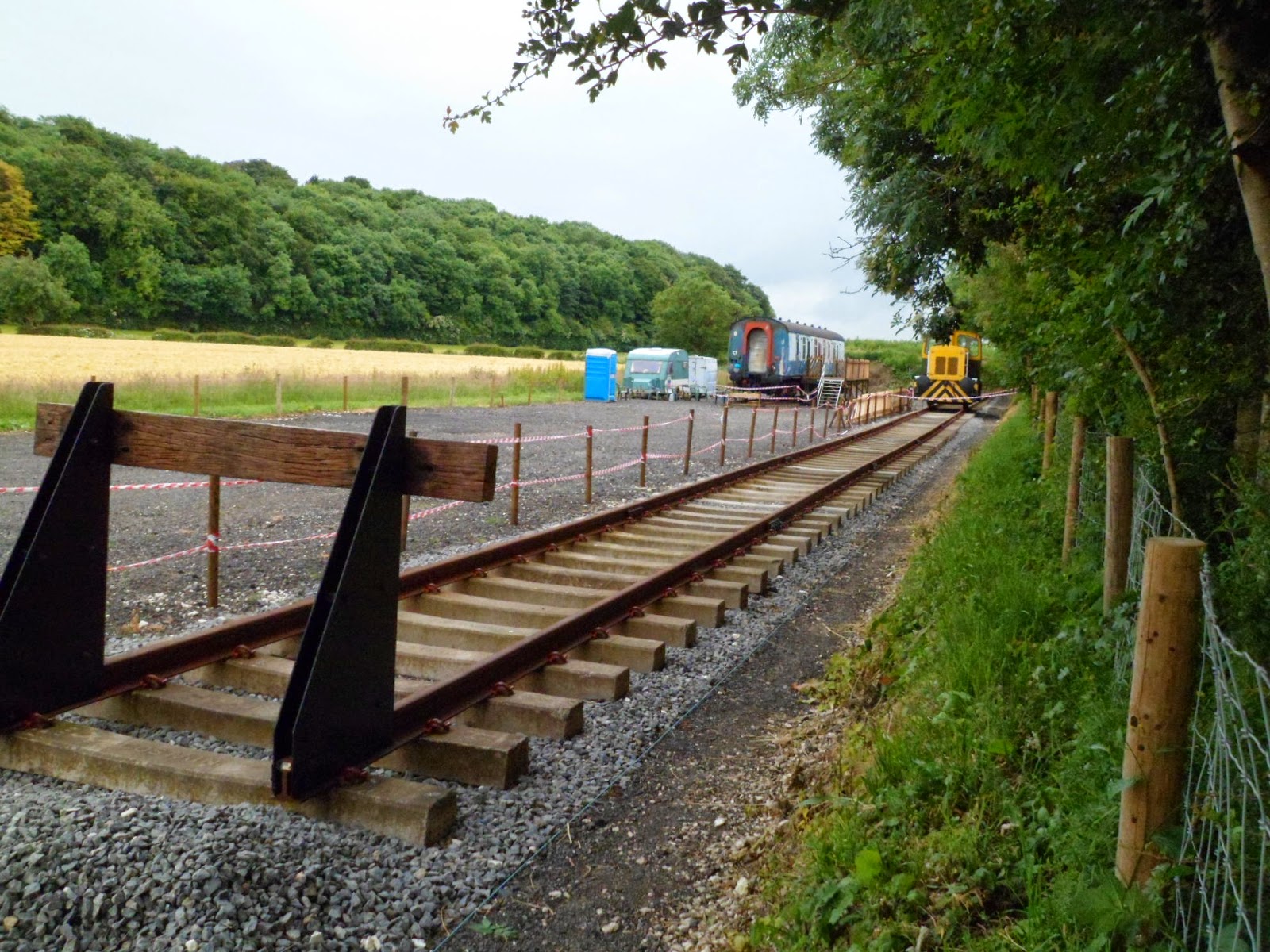
With the old station thoroughly investigated, I set off along the main road, past the crossing keepers' cottage (now a bed & breakfast), to where the Yorkshire Wolds Railway people are establishing themselves. Their site isn't open to the public just yet, but can be easily seen as it's right next the fence - no trespassing required! Hurrah! Their current plan is to run trains from a new station at Fimber Halt (just about visible in the picture, near the yellow shunter) to a terminus at Wetwang Green Lane, and once open it will be the only steam railway in East Yorkshire. Ooooh!

Back in the car (sorry Scott!), and still with the intention of getting to Wharram Percy, I directed Faux-Bro onto a country lane, rather than the main road, on the pretense it was more scenic. After a mile or so, I persuaded him to let me out so I could pose about where Burdale station used to be. At first glance, this looked like it was going to be totally impossible (impassable?) as the station here was on top of an embankment, which is now covered in nettles and brambles, with barbed wire all round it. Oh dear!

Good place to hide a body...
We walked along the fence line, looking for a suitable access point, and eventually stumbled on a way up, but even then, the way back to the station remnants looked totally blocked. As a consolation, I suggested a wander into the old quarry instead, which Faux-Bro accepted as a good substitute. Burdale Quarry is pretty huge, but has been closed nearly as long as the railway line - which shut for good in 1958 - so now it's being colonised by rabbits, orchids, and the occasional bird of prey. I think it might be a nature reserve, but I'm not sure.

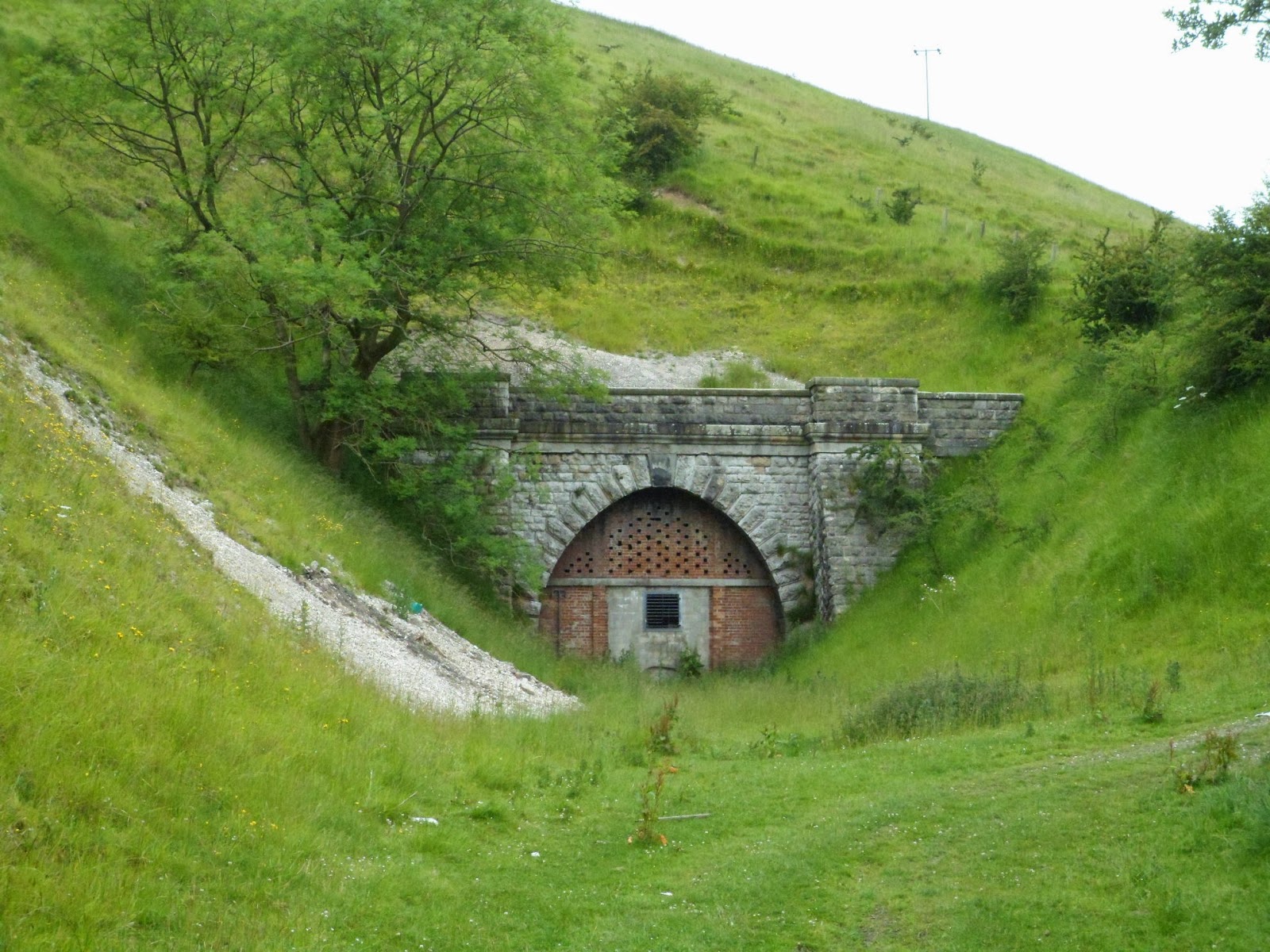
Having now resigned myself to the fact I wasn't going to actually get right up to the station itself, we agreed that a walk along to the tunnel mouth would be a pleasing substitute. After navigating through a herd of cows (who all found it necessary to herald our passing with extravagant squirts of shite), the portal was before us, but was, quite unsurprisingly bricked up, with just a grill part way up for ventilation. Wanting to peer inside, I gripped the rusty metal bars, and pulled myself up to have a look. The grill hinged outwards, like a door, inviting us in...

Descending the ladder inside, into the void, the darkness was positively velvety, and the air much cooler and damper than outside. The tunnel stretched off into total blackness, so we couldn't go too far, not having brought torches. I was inspecting the scratched-in graffiti on the brickwork when all of a sudden Faux-Bro shouted "A skull!", but it wasn't human, just a sheep. Is it odd I was slightly disappointed?

Back out in the open air, after passing back through the still-shitting cows, we walked back towards the car. Somehow, we managed to locate the ruined station platforms, despite seemingly walking the same way we'd already been! There's not much left, just stones poking out of the undergrowth. The main buildings fell down long ago and have returned to nature.
Burdale - not much remains...
But anyway! Onward! 

Time was ticking on, so we drove off, over the head of the valley, to finally get to Wharram Percy. Except we didn't - not straight away anyway. First of all there was the distraction of the opposite end of the tunnel - certainly no exploration possibilities this time though, as the approach cutting is filled with mud and slime and the grill is considerably higher anyway. We had a poke about in a derelict platelayers' hut, and then finally got around to visiting the deserted medieval village.

Irritatingly, despite the pleasant weather all morning, the sky gods decided it would now be a good time to send down some rain! The only place to shelter was the ruin of the church, but that was already occupied by a group of cubs (too young to be proper scouts) messing about and eating sandwiches, so we stood under a tree by the pond and had a quick smoke. 

The rain eventually eased off, so rather than heading straight back to the car park, we walked back to where the old railway line crossed the path, and turned northward towards Wharram's old station. The trackbed here is now used as part of the Centenary Way (I still haven't worked out what it's the centenary of), and is bounded on both sides by bushes. 


Spying an interesting gap in the trees to the east, we slipped through into post-apocalyptic Soviet Russia., or as it's more commonly known: The Wharram Quarry chalk-crusher. With more concrete, rust and broken glass than you could shake a stick at, we were reminded of Pripiyat - the city abandoned after the Chernobyl disaster. It's impressive how nature can gradually reclaim something industrial and ugly, and make it into quite a magical environment. The only sour note was the vast amount of empty shotgun cartridges lying around in heaps...

Not wishing to be peppered with lead, we rejoined the path and very shortly were at the former Wharram station. It's fared considerably better than the other two we visited, and has been converted into a very tasteful private house, but not over-done - it still bears it's railway origins with pride. Even the water tower remains as an unusual garden feature!
Wharram
Adventure time was now done for the day, so we headed back the mile or so to the car. The drive was pleasant - we stopped at the Blue Bell at Weaverthorpe for a pint, and then it was home to feed the cat. All's well that ends well.


Thursday 26 June 2014

An Epic Trek

This week's PlatformCat trek was the most productive yet, thanks in part to my being the proud recipient of a Northern Rail Family & Friends voucher, enabling me to travel anywhere on Northern Rail for the princely sum of £6.00. Rather than just use it on a shopping trip to Primark (as I usually do), I decided to put it to good use. 

I boarded the 10am train to Brid, which was uneventful except for barely concealed disgust at the outfit of the girl sitting across the aisle - footless tights, with socks and Crocs! I was hugely glad when she got off in Filey, otherwise I may have been tempted to slap her round the face. On arrival at East Yorkshire's premier holiday resort (doesn't say much for the rest), I nipped down the side of Tesco's car park and waited for the bus to Hornsea. I've never been on this bus before, and I suspect not many other people have either. It runs twice a day (each way) at this time of year, takes ages, and - being a double decker - crashes through a lot of overhanging branches. Part of the route is rather circuitous too, between Ulrome and Skipsea, the direct road having fallen in the sea at some point recently.

Traditional British summer in Hornsea
I arrived in Hornsea just before midday, in a light drizzle. First impressions were not great, it was grey and overcast and most things looked closed - clearly it was never even in the running to take Bridlington's "Premier resort" crown. The old station (closed in 1965) was nice though, having been converted into attractive houses. There were a couple of information boards about the history of the line I was about to walk (originally the Hull & Hornsea Railway - imaginative naming...) and a big sculpture proclaiming it to be the start (or end, depending on your point of view), of the Transpennine Trail.

Hornsea (aka. Hornsea Town)
The first half mile or so of the path was quite sheltered by trees, which was a blessing as I hadn't bothered to wear waterproof clothing, but even though I got a bit damp it was fairly warm, so not unpleasant. The only downside was the amount of snails crawling about on the tarmac, so I had to do a fair bit of mincing about so as not to crush any of them. 

After the architectural niceties of the town station, the next stop - Hornsea Bridge - was a huge disappointment. As the name suggests, the line was formerly high up on an embankment with a bridge over the main road. Alas, the bridge has been removed in the intervening years, with the gap widened enough to build a roundabout and then what was left of the embankment has been almost entirely nibbled away to make space for an industrial estate. The site of the station is, as a result, a long thin lump covered in scrubby trees. Oh dear... 
Hornsea Bridge - even crapper than Scalby and Hinderwell combined!
A horse, in some fairly dull countryside
But no matter - after Hornsea Bridge, the town abruptly finishes so I was in open countryside. To be honest, it wasn't overly inspiring - the countryside round that area is as flat as a pancake, so that plus the fact I was in a shallow cutting full of trees didn't make for exciting views. It was still raining (so still on snail-watch), but it wasn't far to my next photo-opportunity.

Goxhill, as it was called at the time of the Big Tile Maps, was later renamed Wassand, to avoid confusion with the other, more importany (relatively speaking) Goxhill in North Lincolnshire. I doubt anybody noticed - according to www.disused-stations.org.uk it was only ever open on market days anyway, before eventually closing completely in 1953. It's surprisingly substantial though, considering how little used it must have been. That's the Victorians for you - ever optimistic.
Damp in Goxhill
There then followed another stretch of flat countryside, but at least by this point the rain had stopped, and the sun was breaking through the clouds. The surface of the path changed from tarmac to a sort of rough gravelly stuff, which seemed to discourage snails slightly, and made me very lad I was wearing shoes with tough soles.
Further inspirational views
My next point of call was in the village (more of a hamlet really) of Little Hatfield, so obviously the North Eastern Railway renamed it as "Sigglesthorne" as soon as they got the chance, after a totally different village several miles away to the north. Like Goxhill previously, this station is also a private house. The guidebook I was carrying stated that it was in a state of dereliction, with smashed windows, but was for sale for £60,000 - but my guidebook was printed 25 years ago... Perhaps I need a new guidebook?


Sigglesthorne. Nice station, stupid name.
The next station also continued the trend for illogical naming. Although it was reasonably close to the village of Withernwick, the North Eastern Railway decided to call it Whitedale. There is no village of Whitedale, it is literally just a farm! Even now, there are no other houses within sight of it, but it does have it's own bus stop right outside...
Whitedale
My out-of-date guidebook told me this station was "remarkable" in retaining not just the main station buildings, but also the wooden waiting shelter on the opposite platform. There's no sign of it now, as it has (I believe) been taken away by the North York Moors Railway, and can now be found at Goathland as far as I know... Stolen waiting shelters aside, I noticed it does still have the remains of its coal drops, mouldering away in what used to be the goods yard.

The next station (I'm not even going to try and describe the countryside in between any more - it was just too flat and dull for words!) was Marton, but within less than a year of opening was renamed Burton Constable to avoid confusion with other Martons round and about (another Marton, near Bridlington became Flamborough for the same reason). It stayed thus until the 1920s, when the North Eastern decided that Burton Constable was actually very similar to Constable Burton (not one of the cast of Hearbeat, but a village in Wensleydale), so it was renamed Ellerby, but that's not the end of the story...
Burton Constable? Burton Confusing more like...
Yes, the naming silliness does not end there. The next station shown on the Big Tile Map is... Ellerby! When Burton Constable was still Burton Constable, Ellerby was always just Ellerby, but was closed in 1902 so its name was reused by its neighbour to the north.
Ellerby. Just Ellerby. Nothing more, nothing less.
The station building here has been extended at some point in the past 25 years - the photo in my out-of-date guidebook shows it to be only about half the size of what it is now. I'm not sure if it's the far end or the near end, because it's been done quite sympathetically. Certainly the years have been kinder to Ellerby than they have to the next place I wandered to...
Skirlaugh
I almost completely missed Skirlaugh, as the guidebook said it had been landscaped as a picnic area, so overgrown platforms covered in nettles and brambles wasn't exactly what I was expecting! Admittedly I did see a bench off in the undergrowth to the west, but it wasn't exactly neatly manicured. Perhaps I'd caught it on an off-day?

Other people, almost visible in the distance
At this point I encountered, for the first time today, PlatformCat's arch nemesis, that dreadful thing known as "Other Pedestrians" - and the worst part was, they were walking in the same direction as me, a few hundred yards ahead, but ever so slightly slower, so I knew I would eventually catch up with them, overtake, and possibly even have to make pleasantries! And what's more, from their waddling gait, and tragic nylon-clad silhouettes I could tell they were the worst sort. Old people! 


Of course when I caught up with them, I managed to avert conversation by doing the traditional "Oh look, I'm reading an imaginary text message" with my phone, so I didn't have to make any conversation beyond an "aright". Thank god for modern technology.

Swine (not me, that building behind me)
After my splendid ignorance manoeuvre, I swiftly found myself at the next old station on the line, and just to prove I'm not making its name up, I had to take a picture of the village entrance sign too, 'cos otherwise I'm not sure even I would have believed it was real! 

Very disappointingly I didn't see any pigs, or a pork butchers, or anything even slightly porcine in the local vicinity. I think somebody is missing a great opportunity here...

After crossing the Holderness Drain (it really is as beautiful as it sounds), the scenery now started to become a little less rural. I could see the silhouette of Bransholme - Europe's largest council estate - on the horizon. Now don't get me wrong, I've never been to Bransholme, but being "Europe's largest council estate" is not something I would tell people, but they still do! It's like saying "Glasgow's scruffiest pub toilets", or "Birmingham's biggest sewage works". I personally would try to keep it secret.

Anyway, suburbia was creeping up, with a bit more litter, the odd bit of graffiti now and again, and more roads near by (in fact, any roads near by came as quite a shock). Soon the countryside was almost forgotten and replaced by people's back fences and sad-looking play parks. Didn't see any needles or used condoms though, so it could have been worse. 
Sutton-on-Hull - jogger pissing under bridge not shown.
The last stop before the city begins in earnest was Sutton-on-Hull. Evidently it used to be almost entirely made of wood, so has vanished without a trace except for the road bridge behind me in the picture above. My walk was nearly over - I was hoping to get the 16:11 train back to Scarborough, but alas it was not to be...

Going the wrong way...
My out-of-date guidebook and some seriously crap signposting conspired against me, so once the obvious railway path ended I very quickly got quite lost, and ended up wandering aimlessly around a pre-war housing estate! Luckily a pleasant lady realised my plight, and directed me back in the right direction - apparently I was accidentally walking towards the North Sea ferry terminal! Oops. 

On the plus side, it meant I got to look at some nice Victorian-era Hull & Barnsley railway viaducts, and as I had by this point I had missed the 16:11, it gave me a good plenty of time to call in at Primark...

Something to do with Phillip Larkin
I eventually found my way to Hull's main station - now known as Paragon Interchange 'cos they've sellotaped some bus stops to one side - and I had plenty of time to have a fag in the car park, and a glass of wine in the Pumpkin cafe by the buffers of Platform 3. Well, I say "glass of wine", it was more "large cardboard Costa coffee-cup of wine", but by this point I was truly beyond caring. I was tired, I was hot and sweaty, my feet hurt, my hair appeared to have turned into a bastard crossbreed of Andrew Ridgeley and Rupert Grint, and with getting lost I had done a couple of extra miles round the wastelands and industrial estates of East Hull... 


Hull Paragon
...But I could go home proud in the knowledge that 11 more stations could be crossed off the list. Eleven! Read 'em and weep, as they say... I have no idea what that actually means...


Thursday 19 June 2014

Fyling in a gap

The problem with some stations, is that once they are closed, they become a severe pain in the arse to get to by the remaining public transport. Yesterday's quest proves that. My destination was Fyling Hall - a location on the former Scarborough to Whitby line, serving nowhere in particular. From Ravenscar southward, the route is closely shadowed by a bus service, as is Robin Hood's Bay northward. Unfortunately, due to the local geography, Fyling Hall finds itself in a gap, caused mainly by the pesky North Yorkshire Moors, but I was not to be defeated...

I boarded the 10:15 bus from Scarborough - a single decker, packed full of freeloading pensioners, and after 45 minutes of standing up (for which I paid £5 for the privilege), listening to the inane conversations of Ethel and Fred from Stevenage, I was glad to disembark at the bottom of Thorpe Bank - I'm not sure if the bus made it any further, as it smelled like the brakes were about to burst into flames...

After passing a small council estate (I assume it was a council estate, as one of the gardens had a barking
dog and a trampoline), and a caravan park, I left what passes for civilisation in those parts swiftly behind. I joined the old railway path, at the landscaped remnants of an overbridge, and was quickly engulfed in trees. The old station was soon before me - not that it's very obvious to the casual observer. The stationmaster's house still stands - complete with platform bench - but the platform is almost totally camouflaged, unless you know where to look. What appears to be the trackbed is actually a lane, so to be totally historically accurate I had to hurl myself into the undergrowth, where I was rewarded with some ivy covered fenceposts, a bit of collapsing brickwork, and not a lot else. Still - at least it's better that Scalby... *spit*
Fyling Hall - not so bad
Job done, I continued my journey south. After a flight of steps down to the road - another missing bridge - and back up again, trackbed towards Ravenscar passes over a couple of fairly substantial embankments in quick succession. The views out to sea would probably be quite impressive if it wasn't for all the trees in the way! Eventually, however, the trees gradually disperse, and the whole expanse of Robin Hood's Bay is
revealed. In fact, as the line is on a curve, Robin Hood's Bay can be seen for what seems like miles, and it actually gets a bit boring, but I took a photo anyway. 

A confused deer
It's very remote round here, with just a few farms scattered around. Some of them seem to be only accessible from the trackbed - it makes me wonder how the residents got there when trains still ran. Did they pull the communication cord, and hope the train would stop near their front garden? Or have the roads disappeared back to nature? Either way, I didn't pass a soul for several miles - just a deer, which seemed just as surprised to see me as I was to see it!

My arrival into Ravenscar was preceded by a party of schoolchildren eating sandwiches in the Old Alum Quarry. One of them had dropped a load of Opal Fruits (I refuse to call them by that stupid American name) all over the floor (still in their wrappers) so I gathered them up for sustenance - gotta love a freebie... 

At Ravenscar, the railway footpath makes a brief diversion, as the tunnel is closed to pedestrians, so I meandered through the village, and rejoined the track at Station Square... 

I won't repeat old ground, having covered the next ten miles in a previous post or two. Suffice to say, I carried on all the way back to Scarborough, and got home after about 4 and a quarter hours of walking, and then went to the pub.

Sunday 15 June 2014

Off The Map

PlatformCat would like to apologise for the recent lack of updates - this is due to a cow on the line, or something...

But yeah, anyway, I have been away, to distant lands, but still managed to tick off one station on the map...
This is why I normally use hairspray...

No Ron Weasley sightings...
Centre of the world. Proof.
Mum and I were on our way to The South, and were required to change at that grand pile of architecture that is York - gateway to virtually everywhere in the know universe, or so it seems. Our train was due to depart from platform 9, which gave a good view of the Hogwarts Express, parked over on platform 11 (alas, not 9¾). The engine, masquerading as "Hogwarts Castle", is actually called "Olton Hall" - I travelled behind it from Hellifield to Carlisle once, in the pouring rain, when I was about 17 - and rather appropriately, considering our destination, was built for the Great Western Railway, which leads me rather neatly to the following few places...

Exeter Central
Or rather, it doesn't - due to a total lack of planning on my part (I was on holiday!), the first badly-taken photo is Exeter Central, and although it is now managed by First Great Western, was historically nowt to do with the GWR - it was built by the London & South Western Railway (LSWR) on their main line from Waterloo to Plymouth Friary - now sadly truncated at Meldon Quarry. At the time of the NER tile map it was called Exeter Queen Street, so for historical accuracy, I'll label it as such in the little list over there » » » »


Plymouth

Next up - I think this was Monday (much wine has been drunk since then) - was Plymouth North Road (now just called Plymouth) which was originally a joint venture between the LSWR & the GWR. Architecturally, it's a bit grim. The original buildings were (like most of Plymouth city centre) flattened by the Germans, so are a mix of 1950s/60s brutalist, with odd bits added since. Didn't see any sailors hanging around (insert seamen jokes here).

Torquay

Tuesday we had a trip to Paignton, for a game of crazy golf on the windy seafront. The beach area was totally deserted - I think everyone was in town, wasting their money and junk food and fridge magnets. Rather than just getting the train straight back, we got the "Dart Princess" ferry across the bay to Torquay, and got piss-wet-through while waiting on the quay, in the only rain shower of the week - hence why my hair looks so weird in the photo I took on Torquay station. Although, thinking about it, it looks pretty much the same as usual...

Totnes (Littlehempston)
Wednesday caused a blog-related problem! Not content with the fact I was now posing about in places that are way, way off the North Eastern's tiles, I was now in a station that didn't even exist 'til 1993! Except, to add to the confusion, it sort of did...

Totnes (Littlehempston) aka. Totnes Riverside, is owned by the South Devon Railway, and is the terminus of the branch line up to Buckfastleigh - home of monks and tonic wine. Their steam trains aren't allowed into the main Totnes station - they get in the way so the Fat Controller won't allow it - so the SDR volunteers had to build their own new one next door. Like a giant Hornby trainset, they got ready made buildings from elsewhere, and plonked them down on the platform. The booking office was from Toller Porcorum in Dorset - hence the label at the side. Apologies for not getting a picture of the station sign, but I preferred this one...